


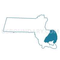
Voting Districts not defined, Barnstable County, Massachusetts
About
Outline

Summary
| Unique Area Identifier | 593639 |
| Name | Voting Districts not defined |
| County | Barnstable County |
| State | Massachusetts |
| Area (square miles) | 894.20 |
| Land Area (square miles) | 0.00 |
| Water Area (square miles) | 894.20 |
| % of Land Area | 0.00 |
| % of Water Area | 100.00 |
| Latitude of the Internal Point | 41.80047590 |
| Longtitude of the Internal Point | -70.00452280 |
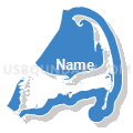
Maps


Graphs
Select a template below for downloading or customizing gragh for Voting Districts not defined, Barnstable County, Massachusetts


Neighbors
Neighoring Voting District (by Name) Neighboring Voting District on the Map
- Barnstable Precinct 1, Barnstable County, MA
- Barnstable Precinct 11, Barnstable County, MA
- Barnstable Precinct 13, Barnstable County, MA
- Barnstable Precinct 4, Barnstable County, MA
- Barnstable Precinct 5, Barnstable County, MA
- Barnstable Precinct 7, Barnstable County, MA
- Barnstable Precinct 9, Barnstable County, MA
- Bourne Precinct 1, Barnstable County, MA
- Bourne Precinct 2, Barnstable County, MA
- Bourne Precinct 3, Barnstable County, MA
- Bourne Precinct 4, Barnstable County, MA
- Bourne Precinct 5, Barnstable County, MA
- Bourne Precinct 6, Barnstable County, MA
- Brewster Precinct 1, Barnstable County, MA
- Brewster Precinct 2, Barnstable County, MA
- Brewster Precinct 3, Barnstable County, MA
- Chatham Precinct 1, Barnstable County, MA
- Chatham Precinct 2, Barnstable County, MA
- Dennis Precinct 1, Barnstable County, MA
- Dennis Precinct 2, Barnstable County, MA
- Dennis Precinct 3, Barnstable County, MA
- Dennis Precinct 4, Barnstable County, MA
- Eastham Precinct 1, Barnstable County, MA
- Falmouth Precinct 1, Barnstable County, MA
- Falmouth Precinct 2, Barnstable County, MA
- Falmouth Precinct 3, Barnstable County, MA
- Falmouth Precinct 4, Barnstable County, MA
- Falmouth Precinct 5, Barnstable County, MA
- Falmouth Precinct 6, Barnstable County, MA
- Falmouth Precinct 7, Barnstable County, MA
- Harwich Precinct 1, Barnstable County, MA
- Harwich Precinct 2, Barnstable County, MA
- Harwich Precinct 3, Barnstable County, MA
- Mashpee Precinct 2, Barnstable County, MA
- Mashpee Precinct 5, Barnstable County, MA
- Orleans Precinct 1, Barnstable County, MA
- Orleans Precinct 2, Barnstable County, MA
- Provincetown Precinct 1, Barnstable County, MA
- Sandwich Precinct 1, Barnstable County, MA
- Sandwich Precinct 2, Barnstable County, MA
- Truro Precinct 1, Barnstable County, MA
- Voting Districts not defined, Bristol County, MA
- Voting Districts not defined, Dukes County, MA
- Voting Districts not defined, Plymouth County, MA
- Wareham Precinct 2, Plymouth County, MA
- Wellfleet Precinct 1, Barnstable County, MA
- Yarmouth Precinct 1, Barnstable County, MA
- Yarmouth Precinct 2, Barnstable County, MA
- Yarmouth Precinct 3, Barnstable County, MA
- Yarmouth Precinct 6, Barnstable County, MA
Top 10 Neighboring County Subdivision (by Population) Neighboring County Subdivision on the Map
- Plymouth town, Plymouth County, MA (56,468)
- Barnstable Town city, Barnstable County, MA (45,193)
- Falmouth town, Barnstable County, MA (31,531)
- Yarmouth town, Barnstable County, MA (23,793)
- Wareham town, Plymouth County, MA (21,822)
- Sandwich town, Barnstable County, MA (20,675)
- Bourne town, Barnstable County, MA (19,754)
- Dennis town, Barnstable County, MA (14,207)
- Mashpee town, Barnstable County, MA (14,006)
- Harwich town, Barnstable County, MA (12,243)
Top 10 Neighboring Place (by Population) Neighboring Place on the Map
- Barnstable Town city, MA (45,193)
- South Yarmouth CDP, MA (11,092)
- East Falmouth CDP, MA (6,038)
- West Yarmouth CDP, MA (6,012)
- Yarmouth Port CDP, MA (5,320)
- East Harwich CDP, MA (4,872)
- East Sandwich CDP, MA (3,940)
- Northwest Harwich CDP, MA (3,929)
- Buzzards Bay CDP, MA (3,859)
- Falmouth CDP, MA (3,799)
Top 10 Neighboring Elementary School District (by Population) Neighboring Elementary School District on the Map
- Brewster School District, MA (9,820)
- Orleans School District, MA (5,890)
- Eastham School District, MA (4,956)
- Marion School District, MA (4,907)
- Oak Bluffs School District, MA (4,527)
- Tisbury School District, MA (3,949)
- Wellfleet School District, MA (2,750)
- Truro School District, MA (2,003)
Top 10 Neighboring Secondary School District (by Population) Neighboring Secondary School District on the Map
- Nauset School District, MA (23,416)
- Martha's Vineyard School District, MA (16,460)
- Old Rochester School District, MA (16,184)
- Nauset/Provincetown School Districts in Turo (7-12), MA (2,003)
Top 10 Neighboring Unified School District (by Population) Neighboring Unified School District on the Map
- Plymouth School District, MA (56,468)
- Barnstable School District, MA (45,193)
- Dennis-Yarmouth School District, MA (38,000)
- Falmouth School District, MA (31,531)
- Wareham School District, MA (21,822)
- Sandwich School District, MA (20,675)
- Bourne School District, MA (19,754)
- Mashpee School District, MA (14,006)
- Harwich School District, MA (12,243)
- Chatham School District, MA (6,125)
Top 10 Neighboring State Legislative District Lower Chamber (by Population) Neighboring State Legislative District Lower Chamber on the Map
- Second Plymouth District, MA (43,508)
- Fifth Barnstable District, MA (40,856)
- Barnstable, Dukes & Nantucket District, MA (40,063)
- Third Barnstable District, MA (38,974)
- First Barnstable District, MA (37,929)
- Second Barnstable District, MA (37,687)
- Fourth Barnstable District, MA (36,909)
- State House Districts not defined, MA (0)
Top 10 Neighboring State Legislative District Upper Chamber (by Population) Neighboring State Legislative District Upper Chamber on the Map
- Plymouth & Barnstable District, MA (172,588)
- First Plymouth & Bristol District, MA (170,671)
- Cape & Islands District, MA (159,761)
- State Senate Districts not defined, MA (0)
Top 10 Neighboring 111th Congressional District (by Population) Neighboring 111th Congressional District on the Map
Top 10 Neighboring Census Tract (by Population) Neighboring Census Tract on the Map
- Census Tract 144.02, Barnstable County, MA (6,947)
- Census Tract 120.01, Barnstable County, MA (5,732)
- Census Tract 145, Barnstable County, MA (5,395)
- Census Tract 5454, Plymouth County, MA (5,294)
- Census Tract 122, Barnstable County, MA (5,046)
- Census Tract 109, Barnstable County, MA (4,942)
- Census Tract 137, Barnstable County, MA (4,911)
- Census Tract 5611, Plymouth County, MA (4,907)
- Census Tract 108, Barnstable County, MA (4,878)
- Census Tract 138, Barnstable County, MA (4,840)
Top 10 Neighboring 5-Digit ZIP Code Tabulation Area (by Population) Neighboring 5-Digit ZIP Code Tabulation Area on the Map
- 02360, MA (56,271)
- 02536, MA (19,583)
- 02601, MA (14,089)
- 02649, MA (14,006)
- 02532, MA (12,690)
- 02632, MA (10,742)
- 02571, MA (10,481)
- 02563, MA (10,359)
- 02631, MA (9,679)
- 02645, MA (9,663)